Ocean Water Masses
Author: Natalie Kuster, Katharina Sperger, Revised by: Aliénor von Roten
Definition
A water mass is a body of water which can be identified by conservative properties (as temperature and salinity) as well as by non-conservative properties.
- A conservative property is a water mass characteristic which has no sinks or sources in the ocean interior. Changes can therefore only be a result of mixing processes occurring at the boundaries (e.g. the ocean surface).
- A non-conservative property is changed in the course of time by chemical, physical or biological processes (other than mixing); e.g. dissolved oxygen, nutrient concentrations.
The study of water masses is of utmost importance such as most of what is known about the three-dimensional circulation of the ocean has been deduced out of it.
Formation
5xQP_B18vMw
Source: http://aquarius.nasa.gov/
There are three major physical processes to form water masses:
- Convection
- Subduction
- Subsurface mixing
Convection is based on an increased density (cooling or evaporation) by contact with the atmosphere. This water mass sinks as long as static stability is reestablished and is beared away from its formation region. Subduction is provoked by wind and cooling. As a result of Ekman pumping, the water mass is carried downward. Subsurface mixing occurs when two or more existing water masses are brought together. The assumption is an appreciable modification of the properties compared to the primordial characteristics.
Nomenclature
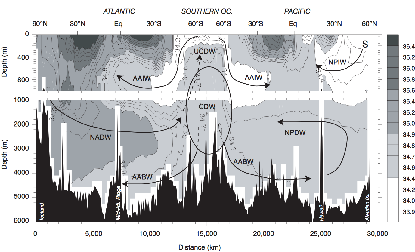
Water masses are typically named according to the location where they originate from and reflect the characteristics of the source region. All abbreviations are determined by the origin of the water masses (first one or two characters, f.e. NA for North-Atlantic) and their final depth (last two characters, f.e. DW for Deep Waters). The figure below overviews the areas of origin of different water masses, salinity and important currents.
- NADW: North Atlantic Deep Water, characterized by relatively high salinity, originates in the Greenland Sea.
NADW is a deep water mass formed in the North Atlantic Ocean. Thermohaline circulation of the world's oceans involves the flow of warm surface waters from the southern hemisphere into the North Atlanic. Water flowing northward becomes modified through evaporation and mixing with other water masses, leading to increased salinity. When this water reaches the North Atlantic it cools and sinks through convection, due to its decreased temperature and increased salinity resulting in increased density. NADW is the outflow of this thick deep layer. NADW and it's formation is essential to the Atlantic Meridional Overturning Circulation (AMOC), which is responsible for transporting large amounts of water, heat, salt, carbon, nutrients and other substances around the globe. NADW has a temperature of 2-4°C with a practical salinity of 34.9-35.0 found at a depth between 1500 to 4000m.
As example a view on the Gulf Stream. The Gulf Stream carries salt into the high latitude North Atlantic where the water cools. The cooling and the added salt cause the waters to sink in the Norwegian Sea. This is the formation of Atlantic Deep Water.
- AAIW: Antartic Intermediate Water.
The AAIW is a cold, relatively fresh water mass (low salinity) found mostly at intermediate depths in the Southern Ocean, above the NADW. The AAIW is formed at the ocean surface in the Antarctic Convergence zone or more commonly called the Antarctic Polar Front zone. The AAIW is unique water mass, because it is a sinking water mass with a moderately low salinity, unlike most sinking water masses which have a relatively high salinity. This salinity minimum, unique to the AAIW, can be recognized throughout the Southern Ocean at depths ranging from 700 to 1200 meters. Typical temperature values for the AAIW are 3-7°C, and a practical salinity of 34.2-34.4 upon initial formation. Due to vertical mixing at intermediate depths in the Southern Ocean, the salinity slowly rises as it moves northward.
The formation of AAIW can be explained very simply through the Ekman transport process and the divergence and convergence of water masses.
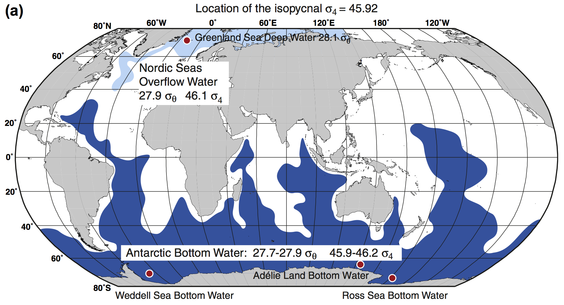
- AABW: Antarctic Bottom Water, the most widespread water mass (found in all three ocean basins, particularly in their southern parts). Originates from the Weddell Sea and is relatively fresh.
Type of water mass in the Southern Ocean surrounding Antarctica. It's the most widespread water mass in the world. Being the densest water mass of the World Ocean, AABW is found in all three ocean basins, particularly in their southern parts. It seems to have two separate source areas: The continental shelf around the continent of Antarctica and deep levels in the Antarctic Circumpolar Current.
Antarctic bottom water is formed in the Weddell and Ross Seas from surface water cooling in polynyas(=area of open water surrounded by sea ice) and below the ice shelf. A unique feature of Antarctic bottom water is the cold surface wind blowing off the Antarctic continent. The surface wind creates the polynyas which opens up the water surface to more wind. This Antarctic wind is stronger during the winter months and so the Antarctic bottom water formation is more pronounced during the Antarctic winter season. Surface water is accumulated in salt from sea ice formation. Because its increased density, surface water flows down the Antarctic continental margin and continues north along the bottom. AABW has a temperature of -0.8 to 2°C with a practical salinity of 34.6 to 34.7 found at a depth below 4000m.
- SAMW: Subantarctic Mode Water, forms the upper part of the AAIW.
SAMW is an important water mass in the Earth's oceans. It is formed near the Subantarctic Front on the northern flank of the Antarctic Circumpolar Current. SAMW is a very homogenous layer that forms north of the Subantarctic Front. SAMW acts as an oxygenator for mid oceanic depths in the Southern oceans. Near the surface it picks up atmospheric oxygen and carbon dioxide and then sinks, or subducts near the Indian Ocean, contributing to the Indian subtropical gyre and cooling and contributing to the Antarctic Circumpolar Current.
- CDW: Circumpolar Deep Water, uniform deep water mass (NADW mixes with other deep waters).
- UCDW: Upper Circumpolar Deep Water, forms the upper part of the CDW.
- LCDW: Lower Circumpolar Deep Water, forms the lower part of the CDW.
- NPIW: North Pacific Intermediate Water, the freshest of all intermediate waters.
- NPDW: North Pacific Deep Water.
NPDW mix with Southern Ocean water to spread along the seafloor into the North Pacific Ocean. Here it upwells to a level of 2,000–3,000 meters and returns to the south lower in salinity and oxygen but higher in nutrient concentrations as North Pacific Deep Water. This North Pacific Deep Water is eventually swept eastward with the Antarctic Circumpolar Current. Modification of deep water in the North Pacific is the direct consequence of vertical mixing, which carries into the deep ocean the low salinity properties of North Pacific Intermediate Water. The latter is formed in the northwestern Pacific Ocean.
Formation: In the NPDW there are no semi-enclosed seas like the Norwegian and Greenland Seas, where water that has acquired characteristic temperature and salinity values can accumulate at depth and entry in the deep water. The formation of deep water masses depends on the production of relatively dense surface water, through cooling and/or increase in salinity. As you know, surface salinities in the Pacific are significantly lower than those in the Atlantic, particularly in the northernmost part of the basin, where values may be 32.0 or less. The Input of freshwater and also the evaporation in the North Atlantic is higher than in the North Pacific. These are the main reasons for the low salinity in the Pacific Ocean and because of their low salinity they are not be dense enough to sink and initiate deep convection. Paradoxically, therefore in the North Pacific, a cool sea-surface prevents the surface layers from becoming sufficiently dense to sink, and there can be no North Pacific Deep Water.
* IODW: Indian Ocean Deep Water.
The deep waters of the Pacific and Indian Oceans are very similar and are sometimes considered as making up one water mass, known as Pacific and Indian Ocean Common Water. Pacific and Indian Ocean Common Water is the largest water mass in the ocean, accounting for about 40% of the total volume.
How is the Pacific and Indian Ocean Common Water formed?
It must be formed through the mixing together of other water masses, specifically Antarctic Intermediate Water, North Atlantic Deep Water and Antarctic Bottom Water. Of these, Antarctic Bottom Water is by far the most voluminous contributor to Pacific and Indian Ocean Common Water. It is a mixture, being about half Antarctic Bottom Water and half Antarctic Intermediate Water plus North Atlantic Deep Water.
Global Distribution
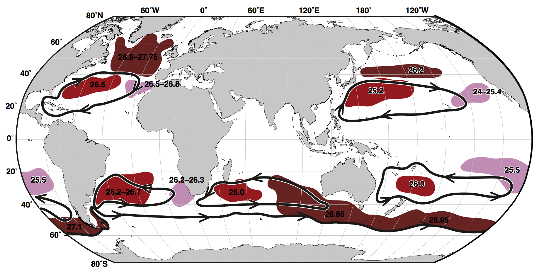
Mode Water Masses (0 - 500 m)
- These are the upper water masses of the oceans that are significantly influenced by surface current patterns. Mode waters are associated with strong fronts, e.g. the Gulf Stream.
- Temperature between 0.0 and 30.0 °C
- Practical salinity between 28.0 and 36.8
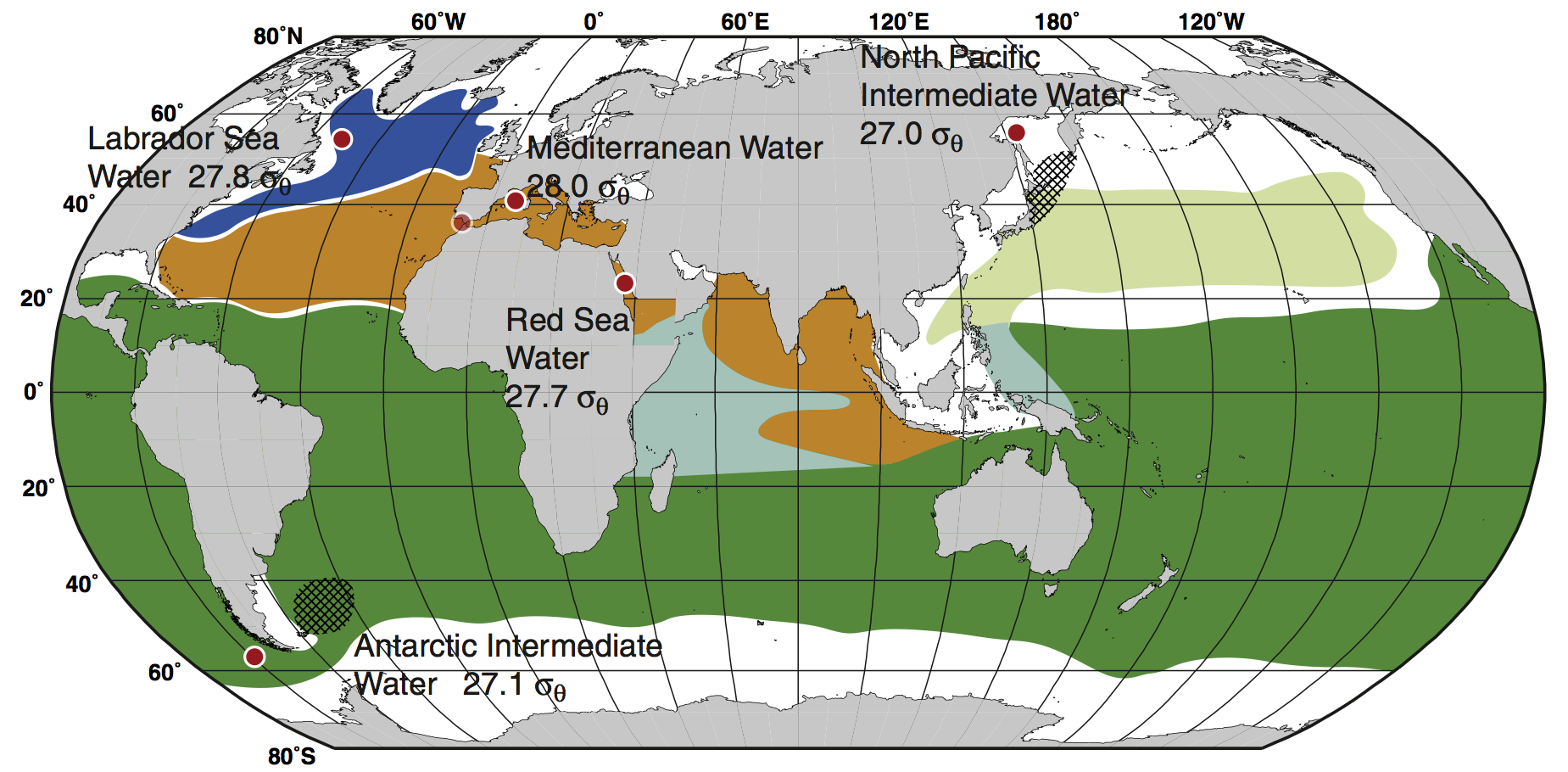
Intermediate Water Masses (500 - 1500 m)
- They are characterized by vertical extrema in salinity
- NPIW or AAIW are examples for low salinity intermediate waters
- Temperature between -1.5 and 14.0 °C
- Practical salinity between 33.8 and 36.2
Deep and Bottom Water Masses (over 1500 m)
- These masses include NADW and AABW. They are formed at the surface by bouyancy loss due to exchange processes.
- Temperature between -10.5 and 4.0 °C
- Practical salinity between 34.62 and 35.0
Non-conservative Tracers
Water masses can also be distinguished by non-conservative, chemical tracers like Radiocarbon $ \Delta ^{14}C $, CFCs, or Oxygen. These measures determine the age of a water mass.
- Radiocarbon is created only in the atmosphere and is absorbed by the ocean afterwards. It decays with a half-life of 5700 years and therefore provides a measure of the last contact with the ocean surface. The oldest water mass is the Pacific Bottom Water with an age of about 2000 years.
- CFCs (Chlorofluorocarbons) have been used as propellants for many decades during the 20th century. Absence of CFC's in water masses is therefore an evidence of age greater than 50-60 years.
- Oxygen: At the ocean surface, the oxygen content of a water parcel is close to saturation. In deeper ocean, there are no sources for oxygen, whereas respiration form considerable oxygen sinks. As a result, low oxygen values indicate older water masses.
TS Diagram
Classical TS Diagram
The most popular tool to describe water masses is the temperature-salinity or TS diagram. It relates density to the measured values of temperature and salinity.
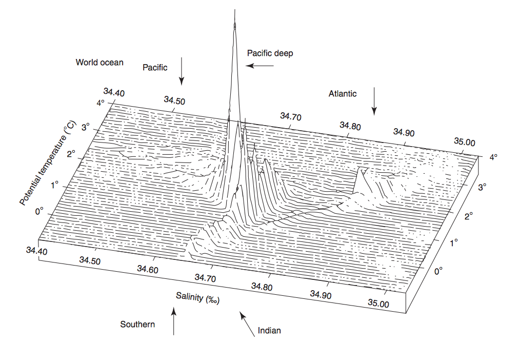
Volumetric TS Diagram
We can also have a look at the volumetric TS curve (three dimensional) - there is illustrated, how much volume is related with a water mass. In this type of plot, the horizontal axes are as before the measured temperature and salinity (coplanar), whereas the upscale part represents the volumes with the appropriate TS properties. As seen in the lecture, only deep water masses are considered (the temperature scale lasts simply from 0 °C up to 4 °C).
References:
- Book Sarmiento and Gruber, 2006, Ocean Biogeochemical Dynamics
- Ocean Circulation, Open University; Chapter 6.3 Ocean Water Masses
- Descriptive Physical Oceanography (Sixth Edition), 2011, Elsevier; Chapter 14 Global Circulation and Water Properties
- Frölicher, 2013, Introduction to Physical Oceanography (lesson 5.3.2014)
- Frölicher, 2015, Introduction to Physical Oceanography (lesson 4.3.2015)
- W J Emery, University of Colorado, Boulder, CO, USA; Copyright 2003 Elsevier Science; Ocean Circulation / Water Types and Water Masses
- Journal of Marine Research, 57, 275-303, Tomczak, 1999; Some historical, theoretical and applied aspects of quantitative water mass analysis
Comments
- I think we should leave the volumetric TS-Diagram in both articles, because here it is usefull to see the volume of different water masses in comparison. (The TS-Diagram article is more technical)
- This is how you insert equations (LaTex-Style): $ \Delta ^{14}C $ (Dollar \Delta ^{14}C Dollar)
( Samuel Eberenz 2015/03/10 10:04 )
